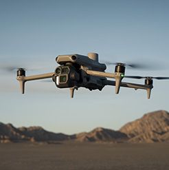
DJI Mavic 3T Thermal Drone
- Dual-Camera System: Combines high-resolution visual and thermal cameras for versatile imaging.
- Advanced Thermal Imaging: 640x512 thermal camera for precise temperature measurement and monitoring.
- 45-Minute Flight Time: Extended battery life for longer, more efficient missions.
- Omnidirectional Obstacle Avoidance: Sensors for safe navigation in complex environments.
- Real-Time Data Transmission: Streams video up to 15 km with low latency for instant decision-making.
- Compact and Portable: Lightweight and easy to deploy, ideal for on-the-go operations.
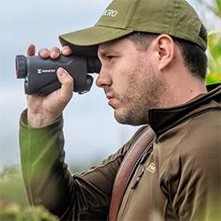
The DJI Mavic 3T is a versatile drone designed to meet the needs of professionals across various industries, with a standout feature being its advanced thermal camera. The 640x512 resolution thermal sensor enables precise temperature measurements, allowing for effective monitoring of heat signatures in real time. This is particularly useful in animal habitat surveying, where the Mavic 3T can track wildlife activity without disturbing their natural environment. By detecting heat sources in dense cover or at night, it provides crucial data for conservation efforts, wildlife monitoring, and tracking animal populations, even in remote or difficult-to-reach areas.
Beyond wildlife observation, the Mavic 3T is equally adept at mapping and surveying. With RTK (Real-Time Kinematic) support, it delivers centimeter-level accuracy, making it ideal for creating detailed, precise maps for land management, agriculture, and construction projects. Whether for monitoring environmental changes, surveying large areas, or conducting land assessments, the Mavic 3T’s ability to capture both thermal and high-resolution visual imagery ensures comprehensive data collection.
The Mavic 3T also integrates seamlessly with DJI FlightHub 2, DJI’s cloud-based management platform. This compatibility allows for efficient mission planning, fleet management, and real-time data analysis, making it an excellent tool for larger-scale operations and collaborative fieldwork.
With its powerful thermal imaging, high-resolution mapping features, and integration with FlightHub 2, the Mavic 3T stands as the ideal solution for affordable, high-quality thermal aerial imagery. Whether you’re working in wildlife conservation, agriculture, or industrial inspections, the Mavic 3T offers unmatched performance at a cost-effective price, making it the perfect tool for any professional requiring reliable and precise thermal data.
- Weight (with propellers, without accessories) 920 g
- Max Takeoff Weight 1,050 g
- Dimensions Folded (without propellers)
- Diagonal Distance 380.1 mm
- Max Ascent Speed 6 m/s (Normal Mode)
- Max Descent Speed 6 m/s (Normal Mode)
- Max Flight Speed (at sea level, no wind) 15 m/s (Normal Mode)
- Max Wind Speed Resistance 12 m/s [3]
- Max Take-off Altitude Above Sea Level 6000 m (without payload)
- Max Flight Time (no wind) 45 mins [4]
- Max Hover Time (no wind) 38 mins
- Max Flight Distance 32 km
- Max Pitch Angle 30° (Normal Mode)
- Max Angular Velocity 200°/s
- GNSS GPS+Galileo+BeiDou+GLONASS (GLONASS is supported only when the RTK module is enabled)
- Hovering Accuracy Vertical
- Operating Temperature Range -10° to 40° C (14° to 104° F)
- Internal Storage N/A
- Motor Model 2008
- Propeller Model 9453F Propellers for Enterprise
- Beacon Built into the aircraft
- Class C2 (EU)
- Wide Camera Sensor 1/2-inch CMOS, Effective pixels
- Wide Lens FOV
- Wide ISO Range 100-25600
- Wide Shutter Speed Electronic Shutter
- Wide Max Image Size 8000×6000
- Wide Camera Still Photography Modes Single
- Wide Video Resolution H.264
- Bitrate 4K
- Zoom Camera Sensor1/2-inch CMOS, Effective pixels
- Zoom Lens FOV
- Zoom ISO Range 100-25600
- Zoom Shutter Speed Electronic Shutter
- Zoom Max Image Size 4000×3000
- Digital Zoom 8x (56x hybrid zoom)
- Thermal Camera Uncooled VOx Microbolometer
- Thermal Camera Pixel Pitch 12 μm
- Thermal Camera Frame Rate 30 Hz
- Thermal Camera Lens DFOV
- Thermal Camera Noise Equivalent Temperature Difference (NETD) ≤50 mK@F1.0
- Temperature Measurement Method Spot Meter, Area Measurement
- Temperature Measurement Range -20° to 150° C (-4° to 302° F, High Gain Mode)
- Thermal Palette White Hot / Black Hot / Tint / Iron Red / Hot Iron / Arctic / Medical / Fulgurite / Rainbow 1 / Rainbow 2
- Thermal Digital Zoom 28x
- Thermal Infrared Wavelength 8-14 μm
- Infrared Temperature Measurement Accuracy ±2° C or ±2% (using the larger value)
- RC Video Transmission System DJI O3 Enterprise Transmission
- RC Max Transmission Distance (unobstructed, free of interference) FCC
- RC Video Transmission Operating Frequency 2.400-2.4835 GHz
- RC Antenna 4 Antennas, 2T4R
- RC Video Transmission Transmitter Power (EIRP) 2.4 GHz
- RC Wi-Fi Protocol 802.11 a/b/g/n/ac/ax
- RC Wi-Fi Operating Frequency 2.400-2.4835 GHz
- RC Wi-Fi Transmitter Power (EIRP) 2.4 GHz
- RC Bluetooth Protocol Bluetooth 5.1
- RC Bluetooth Operating Frequency 2.400-2.4835 GHz
- RC Bluetooth Transmitter Power (EIRP) < 10 dBm
- RC Screen Resolution 1920×1080
- RC Screen Size 5.5 inches
- RC Touchscreen Control 10-point multi-touch
- RC Battery Li-ion (5000 mAh @ 7.2 V)
- RC Rated Power 12 W
- RC Storage Capacity Internal Storage (ROM)
- Charging Time Approx. 1 hour 30 minutes (with the included DJI USB-C Power Adapter (100W) only charging the remote controller or a USB charger at 15 V)
- RC Operating Time Approx. 3 hours
- RC Video Output Port Mini-HDMI port
- RC Dimensions Antennas folded and controller sticks unmounted
- RC Weight Approx. 680 g
- RC Model RM510B
- Advanced Thermal Imaging: 640x512 thermal camera for precise heat signature detection.
- High-Resolution Visual Camera: 20MP camera with 4K video for clear, detailed imagery.
- Zoom Functionality: 56x hybrid zoom for detailed inspections from a safe distance.
- RTK Support: Centimeter-level precision for accurate mapping and surveying.
- 45-Minute Flight Time: Extended battery life for longer missions and greater coverage.
- Omnidirectional Obstacle Avoidance: Sensors to ensure safe navigation in all directions.
- Real-Time Data Transmission: Up to 15 km range with low-latency video streaming.
- DJI FlightHub 2 Compatibility: Seamless fleet management, mission planning, and real-time data analysis.
- Compact and Portable Design: Easy to deploy and transport for on-the-go operations.

